Ivalojoen packraft melonta Kuttura - Lappispola/Ivalojoki paddling with packraft Kuttura-Lappispola
- Niko Takala

- 14.10.2020
- 18 min käytetty lukemiseen
Päivitetty: 3.3.2021
You can find the english translation below the finnish text
8.7.2020 aloitin minun ensimmäisen kunnon packraft melontavaelluksen, jossa olisi myös koskia tiedossa. Olen melonut packraftillä siis aiemminkin. Mm. kesällä 2019 olin Vätsärin erämaa-alueella viikon vaelluksella sen kanssa, mutta koskia en ollut aiemmin kokenut sillä. Ensikosketukseni koskimelontaan sain eräopasopiskelujeni aikana. Silloin kävimme luokkani kanssa itäsuomessa melomassa Jongunjoella avokanooteilla n. 60 km. Aloitimme silloin Jonkerin kodalta, ja lopetimme lähes heti Viitakosken jälkeen vasemmalla puolella olevalle lopetuspaikalle. Eli silloin tuli opittua kantapäänkautta koskenlukua, ja minkälaista on kaatua avokanootilla koskessa. Sitä meinaan tuli harrastettua ensimmäisenä päivänä siellä ihan riittävästi. Mutta sitten Ivalojoelle. Lähdin liikenteeseen Kutturasta, jonne jätin autoni parkkiin. Siellä on ihan asiallinen parkkipaikka melojien autoille, ja on myös helposti löydettävissä. Parkkipaikka on merkattu myös maastokarttoihin. Noin klo 11 aikoihin sain purettua autostani kaikki kamppeet, ja olin lähtövalmiina tulevaa koitosta varten. Kaikki varusteeni kulki vedenpitävässä laukussa, jonka sitten sidoin packraftin keulaan kiinni. Ja koskimelonnassa melojan vakiovarusteita on tietysti myös kypärä ja liivit. Kutturasta lähdettäessä ensimmäiset 3 kilometriä ovat ihan sileää vettä ilman koskia, jossa saa vielä hengähtää ja ottaa tuntumaa rauhassa melontaan. Keli oli minulle erittäin suotuisa. Aurinko paisteli puolipilviseltä taivaalta ja sain meloa t-paita ja shortsit päällä. Aina ennen reissua on pieni alku jännitys päällä, mutta kun pääsin vesille ja olin ottanut ensimmäiset metrit meloen, niin sitten ei voinut kuin nautiskellen päästää menemään. Vaikka ensimmäiset kosket tulevat vasta kolmen kilometrin jälkeen, niin joki virtasi oikeastaan koko matkan kyllä aina alaspäin jollain nopeudella, että paljoa ei ollut kyllä täysin seisovaa vettä. Joen virtaus oli noin 90 - 95 kuutiota/sekunti, jonka totesin ihan sopivaksi ensimmäisellä reissulla. Jokien korkeudet ja veden virtausnopeudet yms. näkee kätevästi netistä vesi.fi sivulta. Sieltä näkee myös historiaa taaksepäin ja mm. menneitä tulvahuippuja ja niiden ajankohtia on sieltä kätevä katsella. Kiviä ei tarvinnut paljoa väistellä packraftillä ja meno isommissa koskissa oli riittävä. Eli ensimmäisetkin kilometrit taittuivat todella nopeasti ja sitten oltiinkin ensimmäisten koskien parissa. Luontoon.fi sivulta löytää muuten tälle Kuttura - Ivalo välille koskinuotit, josta näkee että mikä koski tulee missäkin kohtaa ja siinä kerrotaan suositeltu laskulinja. Koskiahan tällä pätkällä on n. 30 kpl eli tarkkana saa olla kartan ja nuottien kanssa, että lukee oikeaa nuottia oikean kosken kohdalla jos nuotteja aikoo seurata. Minä luin ja katselin nuotteja saarnakönkäälle asti, ja sitten rupesin ajattelemaan että onko niistä ollut tähän asti hyötyä ja olenko laskenut kosket niiden mukaan. Ja tulin siihen lopputulokseen että eiköhän katsota nuoteista vain nämä etukäteen tarkastettavat kosket, ja muihin sitten melon omia katsomiani linjoja pitkin. Niin lopetin sitten niiden turhan tarkan tuijottamisen. Ja sain huomata kyllä reissun aikana että se kannatti, koska kosken lukutaito kehittyi kyllä aika lailla tämän parin päivän aikana.


Ensimmäiset kosket ovat helppoja 1- luokan koskia aina Saarnakönkäälle asti. Saarnaköngäs tulee 9 km kohdalla, joka on syytä ennakko tarkastaa maitse. Rantauduin könkään vasemmalle puolelle, ja pidin siinä sitten lounastauon samalla kun tuijotin koskea. Rannassa niitä nuotteja katsoessani huomasin että niissä luki, että olisi kannattanut mennä könkään oikealle puolelle ennakkotarkastamaan se, mutta mielestäni vasemmalta puolelta näki riittävän hyvin ja niinpä annoin lounaan syönnin jälkeen sitten mennä. Ja sehän sujui oikeinkin hyvin ja oli todella kiva kokemus. Niinkin kiva että päätin laskea sen vielä toisenkin kerran. Toinen kerta ei mennyt ihan niin hyvin vaan ajauduin liiaksi linjan oikeaan reunaan ja otin pienen osuman pudotuksen kohdalla olevaan kiveen, mutta se ei aiheuttanut toimenpiteitä vaan pääsin kosken alas lopulta hyvin. Mutta sen verran jäi kaivelemaan että en minä tuollaisen suorituksen jälkeen kyllä tästä lähde vaan laskin sen vielä kolmannenkin kerran joka meni sitten kuin ensimmäinenkin kerta eli lähes kuin oppikirjasta.
Nyt sain hyvillä mielin jatkaa matkaa vatsa täynnä. Saarnakönkään jälkeen seuraava kiva koski on Penttilänkoski, joka on 3 km päässä Saarnakönkäästä. Penttilänkoskessa on kivoja isoja aaltoja, ja yhden stopparinkin löysin koskesta. Eli koskessa oli yksi niin voimakas vasta aalto, että kun meloin sitä päin, niin se otti vauhdin pois aika tehokkaasti.
Penttilän koskea seuraa miltei heti Saarikorva koski ja sen jälkeen Anelinkorva, joka on köngäsmäinen lyhyt koski, josta on alla tyylinäyte. Ja pahoittelut kielenkäytöstäni alla olevalla videolla jo etukäteen.
Ja niin kuin videollakin osuvasti totesin niin packraftin sisään tuli joissain koskissa aina jonkun verrankin vettä, kun aallot pyyhkivät siitä kannen yli niin sanotusti. Ja aina välillä isoimpien koskien jälkeen joutui rantautumaan ja kallistamaan sitä sen verran että vedet valuivat sieltä pois. Mutta se nyt on todella pieni juttu eikä vie aikaa juuri mitään.

Anelinkorvan jälkeen onkin enää noin 4 km matkaa Ivalojoen Kultalaan johon päättäisin ensimmäisen päiväni. Kosket tuolla välillä ovat mukavia ja helpohkoja. Viimeinen koski ennen Kultalaa on saunakoski, jonka jätin vielä laskematta eli rantauduin joen oikealle puolelle hieman ennen joen yli menevää riippusiltaa. Tein näin koska olin etukäteen katsonut että riippusilta on remontissa eikä siitä pääse kävelemään joen yli. Sillä halusin lähteä vielä katselemaan maisemia vielä hieman korkeammalta. Eli riippusillalle tulee polku vaarojen päältä, josta pääsee kävelemään mm. pahaojalle. Mutta nyt kävelin vain ne rappuset ylös jotka lähtevät riippusillan luota vaaran päälle. Ja kyllähän sieltä hyvät näkymät joelle aukesivatkin. Eli kannatti kiivetä muutama rappunen.


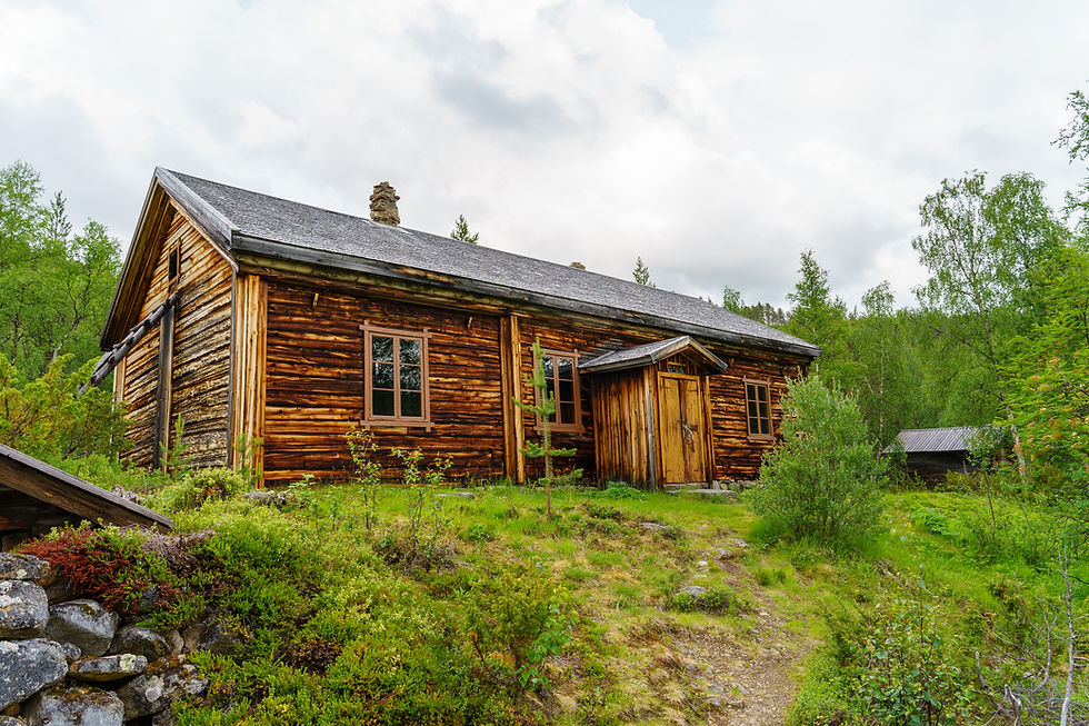
Kun olin tovin ihmetellyt ja ottanut riittävästi valokuvia niin lähdin kävelemään rappuset alas takaisin joelle ja sitten laskin viimeisen kosken ja rantauduin Ivalojoen Kultalaan. Rantaan päästyäni huomasin että rannalla oli kaksi avokanoottiakin eli oli siellä jotain elämää. Ihan siinä joen rannassa oli sellainen pieni mökki liekö sauna mutta se oli lukossa joten sisään ei nähnyt kuin ikkunoista. Rannasta on pieni nousu siihen tasanteelle, jossa Kultalan kaikki ne rakennukset ovat. Tasanteelle tultuani aloin ensimmäiseksi ihmettelemään että mikä mikin rakennus on, ja sehän selvisi sellaisesta opas taulusta, johon oli laitettu vähän historiaakin alueesta. Käppäilin sitten autiotuvallle katsomaan että mikä meininki siellä on ja sain huomata että siellä oli neli henkinen lapsiperhe. Tupa oli sen verran iso että mahduin hyvin vielä sekaan. Sitten menin kiertelemään ympäri niitä rakennuksia ja räpsin niistä valokuvia. Kaikki rakennukset olivat kyllä tosi hienoja. Sitten myöhemmin Kultalaan saapui vielä neljä henkilöä lisää, jotka olivat myös tulleet packrafteillä mutta he majoittuivat telttoihinsa pihalle. Siinä se ilta sitten meni syödessä ja levätessä ja odottaen seuraavan päivän koitoksia.


Seuraavana aamuna heräsin joskus klo 7 aikoihin ja pakkasin tuvasta tavarani ja lähdin ulos tekemään aamupalaa ja annoin muiden jäädä rauhassa nukkumaan tupaan. Aamupalana on aina puuro mysli sekoitusta ja kaakaota. Minulla ei ollut päivälle mitään suunnitelmaa että miten pitkälle tänään melon. Vaan ajattelin että katsotaan sitten illalla, mihin päädytään. Edellisenä päivänä olin tullut 18 km 3 h + kaikki tauot. Mutta siis tehokasta melontaa oli tuo 3 h eli aika lujaa virta vie kyllä alaspäin. Mutta jahka olin saanut kamat kasaan ja syötyä niin oli aika lähteä jatkamaan matkaa. Ja matkaan pääsin n. klo 9. Ja ensimmäinen koski tulikin jo n. 500 m melonnan jälkeen. Ja se on Kultalankoski, jossa on myös isohkoja aaltoja ja taas kerran todella siisti koski laskettavaksi.

Ja Kultalankoskea seuraa miltei heti Kolmosenkoski, jossa riittää myös vauhtia ja hyviä aaltoja. Eli tuli oikein mukava päivän alku toiselle päivälleni.
Seuraavan n. 10 km aikana Kolmosenkosken jälkeen tulee n. 7 eri koskea, jotka ovat helpohkoja laskea ja virta kuljettaa mukavasti vauhdilla alaspäin kokoajan. Tuolle osuudelle osuu kaksi autiotupaa. Toinen on n. 6 km jälkeen oleva Liljeqwistin kämppä, ja toinen on Ritakosken autiotupa, joka on tuolla osuudella n. 9 km jälkeen. Tuvan kohdalla on pitkähkö koski nimeltään Ritakoski, jossa olikin muutama kalastaja heittelemässä rannalla. Reilu 500 m Ritakosken jälkeen oikealla puolella jokea tulee hiekkaranta johon jäinkin sitten syömään lounasta. Paikka oli lähes täydellinen ja keli oli myös erittäin komea.


Kun rantauduin ja lähdin vähän kävelemään siihen rannalle ihmettelemään paikkoja, niin yhtäkkiä silmään osui hauenraato ja sehän pisti miehen vähän säpsähtämään. Hauki oli noin 2 - 3 kg luokkaa, mutta siitä ei ollut jäljellä kuin pää ja luuranko. Hyönteiset olivat puhdistaneet hauen huolella ja oli se sen näköinenkin, että se siinä auringossa oli jo jokusen päivän paistunut. En vaan voi ymmärtää miksei kalastajat voi haudata perkuu jätteitään vaan pitää jättää perattu hauki siihen keskelle rantaa. Mutta se siitä hauesta. Ivalojokeen laski myös Palsinoja eli pieni oja, joka oli kyllä myös hieno. Rannalla oli muiden retkeilijöiden tekemä nuotiorinkikin, jonka äärellä sitten söin lounaani. Sitten oli aika taas jatkaa matkaa. Olin tähän mennessä melonut tänään sen n. 10 km, ja kello oli jotain 11 - 12 väliltä kun jatkoin matkaa. Minkäänlaista suunnitelmaa päivälle ei ollut vaan aioin vaan meloa jokea alaspäin omaa rauhallista tahtia, ja katsoa taas mistä itseni illalla löydän. Nyt taas seuraavalla 10 km pätkällä tuli viisi eri koskea jotka olivat helppoja, mutta taas mukavia lasketella. Ja kun aurinko paistaa kirkkaalta taivaalta niin mikäs sen mahtavampaa. En pystynyt nyt aamulla katsomaan että mikä oli joen virtaus nopeus tänään, koska joen kanjoni osuudella ei saa yhteyttä puhelimella. Mutta itsestäni kyllä tuntui, että se oli laskenut yön aikana jonkin verran. Sen verran helpoilta kosket tuntuivat eiliseen verrattuna. Lounaspaikaltani n. 4 km kun melotaan jokea alaspäin, niin joen oikealla puolella on karttoihinkin merkitty matkailunähtävyys. Ja tämä nähtävyys oli Ivalon kullan ensimmäinen löytöpaikka, jonka kunniaksi on sitten laitettu kyseiselle paikalle pieni muistomerkki, jota kävin tietenkin katsomassa.


Muutaman sadan metrin jälkeen nähtävyydestä tuleekin sitten Louhiojan autiotupa. Mutta koska kello oli vasta niin vähän niin en sitten edes miettinyt että jäisin vielä tähän yöksi vaan jatkoin matkaa alaspäin. Ja sitten n. 9 km myöhemmin löysin itseni Toloskosken yläsuulta joka olisi tämän reissun viimeinen koski joka on myös tarkastettava etukäteen. Louhijoen autiotuvan jälkeen ei siis ollut kuin muutama helppo koski ja sain vain päästellä jokea rauhassa alaspäin. Toloskoskeen kuuluu sekä ylä- että ala osuus eli koski on ns. kaksiosainen. Yläosa näytti todella helpolta joten käppäilin sitten kosken alaosaan, joka näyttikin sitten vähän kinkkisemmältä. Koski oli aika leveä, joten kun olin nyt joen vasemmalla puolella tarkastamassa koskea niin en nähnyt kunnolla joen oikeaan rantaan, että mitä siellä oli, mutta koska joen vasen ranta näytti siltä että siitä on ainakin ihan mahdotonta mennä, niin linjan piti sitten olla oikealla puolen rantaa. Sen verran näin sinne oikealle rannalle että siellä on kosken loppuosassa ainakin kohtuullista aallokkoa eli eiköhän se laskulinja siellä mene. Ja niinpä sitten kävelin takaisin packraftilleni ja lähdin laskemaan koskea alas. Ja niinhän se oli että yläosa oli todella helppo jossa ei ollut mitään ihmeellistä. Yläosan jälkeen pysähdyin vielä tarkastelemaan oikealle puolelle rantaa packraftistäni sitä alaosaa että miltä se näyttää ja totesin että siinähän se linja menee ja annoin sitten mennä.
Ja sehän oli tosi siisti koski, joka meni myös tosi hyvin. Ehdottomasti tämän reissun top 3 koskiin pääsi. Ensin ajattelin koskenlaskun jälkeen, että tähän kosken alaosaan voisi jäädä vaikka yöksi. Tai vaikka yläosankin puolelle sillä olin nähnyt siinä ihan hyviä telttapaikkoja, kun olin tarkastamassa koskea. Mutta sitten kun menin taas sinne pusikkoon, niin siellä odotti sellainen hyttys/ötökkäarmeija että meikäläisen hermot ei sitä kestä. Tähän asti olin tänä päivänä melonut n. 27 km, ja kello rupesi olemaan jo neljä iltapäivällä. Siinä sitten mietin että tästä on vielä 5 km Lappispolaan, jonne tämä reissu on tarkoitus lopettaa, ja siitä pitää sitten vielä siirtyä taksilla Kutturaan. Ja siinä menee tunti aikaa eli olisin noin kuudelta sitten Kutturassa takaisin autollani, ja siitä sitten ajaisin Saariselälle yöksi. Niin ajattelin ettei se nyt niin paha rasti ole että eiköhän mennä. Ja niinpä lähdin sitten melomaan viimeisen 5 km. Tällä matkalla ei ole koskia, eikä vesikään virrannut oikeastaan vaan nyt oli mentävä täysin lihasvoimalla. Ja noin tunti siinä vierähti ja saavuin Lappispolan veneenlaskupaikalle ja soitin taksin. Ja sieltä sitten sanottiin että menee n. 20 min. Niin sillä välin kerkesin sitten pakkaamaan varusteeni kasaan ja niinpä nousin taksin kyytiin ja tämä reissu oli paketissa. Huikea ensimmäinen koskimelontareissu packraftilläni yksin oli nyt takana. Tästä oli sitten hyvä jatkaa matkaa Kilpisjärvelle, josta alkaisi sitten ylihuomenna seuraava hieman pidempi ja haastavampi melontareissu. Tähän loppuun vielä muistutus että koskimelonnassa on aina itse todettava kunkin kosken olosuhteet sillä hetkellä itse kun on koskia laskemassa. Koska koskien luonne muuttuu täysin virtausnopeuksien ja veden korkeuden mukaan. Eli laskulinjat voivat olla erilaiset eri vedenkorkeudella. Ja sitä kannattaa myös aina miettiä että millä välineellä olet laskemassa koskia. Minä laskin nyt packraftilläni joka menee aika pinnassa ja jos itse olet vaikka menossa kanootilla laskemaan koskia niin laskulinjat voivat olla ihan erilaiset koska kanootilla osuu kiviin todella paljon helpommin koska se ui huomattavasti syvemmällä. Eli muista tarkastaa olosuhteet aina itse paikan päällä.
The english translation starts here
On July 8, 2020, I started my first decent packraft paddling trip, which would also feature rapids. I have paddled with packraft also before. In the summer of 2019, for example, I was in the Vätsäri wilderness area for a week trekking with it, but I had never experienced rapids with it before. I got my first touch with rafting during my wilderness guide studies. That's when we went with my class in eastern Finland to paddle on the river Jongunjoki with canoes for about 60 km. We then started from the Jonkeri tepee, and almost immediately after rapid Viitakoski we ended the trip on the left side of the river. That is, it was then that we learned how to read the rapids after many mistakes, and we get to feel many times what it’s like to fall off an open canoe in a rapids. So we fell quite many times with the canoe in the rapids during the first day. But then back to Ivalojoki. I started canoeing from Kuttura, where I also left my car in the parking area. There’s a pretty decent parking area for paddlers ’cars, and it’s also easy to find. The parking area is also marked on terrain maps. Around 11 a.m., I managed unloaded all the gear from my car, and I was ready to face the new challenges. All my gear went in a waterproof bag, which I then tied to the bow of the packraft. And, of course, a helmet and a personal floating device are standard equipment's for paddling in whitewater. From Kuttura, the first 3 kilometres are just calm water without rapids, where you can like relax for a while. The weather was very favourable for me. The sun was shining from the partly cloudy sky and I paddled with a t-shirt and shorts on. There’s always a small excitement before the trip, but when I got on the water and had taken the first meters of paddling, then I just let go and enjoy. Although the first rapids only come after three kilometres, the river actually flowed all the way down at some speed, that there wasn't much standing water. The flow of the river was about 90 to 95 cubic meters per second, which I found quite suitable for the first rafting trip. River heights and water flow rates, etc. can be conveniently viewed online on the vesi.fi page. From there you can also see the history backwards and e.g. past flood peaks and their times are convenient to watch from there. There was not much need to dodge rocks with packraft because the water height was so good and the biggest rapids were also difficult enough. In other words, even the first kilometres folded really fast and then we were on the first rapids. By the way, on the Luontoon.fi page you can find rafting notes for the section between Kuttura and Ivalo, where you can see what rapid is coming and when and it tells you the recommended canoeing line as well. This section have about 30 pieces of rapids, so you must be precise with the map and the notes that you read the right note at the right time if you plan to follow the notes. I read and watched the notes all the way to the Saarnaköngäs which is the first rapid that you should inspect in advance by land before paddling it. And then I started to think about whether the notes have been useful so far and
have I paddled rapids according to them. And I came to the conclusion that I only check from notes those rapids that must be checked in advance, and then paddle the others along the lines that I watch best at myself. So I stopped staring at them too much. And I did notice during the trip that it was worth it, because the rapids literacy developed pretty much during this couple of days.
The first rapids are easy 1-class rapids all the way to Saarnaköngäs. Saarnaköngäs comes after 9 km, which is worth checking in advance by land. I went on shore the left side of the river, and then took a lunch break there while staring at the rapid. When I looked at those notes on the beach, I noticed that they said that it would have been better to go to the right side of the river to pre-check it, but I thought that I saw good enough from the left side and so after I finished the lunch I let it go. And it went really well and it was a really nice experience. So nice that I decided to try it one more time. The second time didn’t go quite so well because I drifted too far to the right edge of the line and took a small hit on the rock at the drop, but it didn’t cause any trouble and I survived for it well in the end. But it was left digging my mind so much after such a performance, I didn't want to leave here yet, so I decided to try it for the third time, which then went like the first time, so almost like from a textbook.
Now I was happy to continue the journey with my stomach full. After Saarnaköngäs, the next nice rapid is Penttilänkoski, which is 3 km from Saarnaköngäs. There are nice big waves in Penttilänkoski, and I found one stopper in the rapids as well. So in rapid there were one so powerful counter wave that when I paddled towards it, it took the speed off pretty effectively.
The Penttilä rapids are followed almost immediately by the Saarikorva rapids and then by the Anelinkorva, which is like lingering short rapid with a style sample below. And apologies for my language use in the video below in advance.
And as I aptly stated in the video, there went always some water inside the packraft after bigger rapids as the waves swept it over the deck, so to speak. And always after the biggest rapids sometimes I had to go to shore and tilt it so much that the waters flowed out of there. But that’s a really small thing now and takes almost no time.
After Anelinkorva, it is only about 4 km to Kultala on the Ivalojoki River, where I would end my first day. The rapids in that section are nice and easy. The last rapid before Kultala is the sauna rapid, which I left paddled yet, and I went on shore on the right side of the river just before the suspension bridge over the river. I did this because I had previously discovered that the suspension bridge was being renovated and you would not be able to walk across the river from it. For I wanted to go to look at the scenery from a little higher. In other words, there will be a path over the fells to the suspension bridge, from where you can walk e.g. to the pahaoja parking lot. But now I only walked up the stairs that started from the suspension bridge and went top of the fell. And from there, were good views to the river. So it was worth it to climb a few stairs.
After a moment of wondering and snapping enough photos, I went back down the stairs to the river and then I paddled the last rapid and went ashore of the Kultala. When I got to the beach, I noticed that there were two canoes on the beach, so there was some life. Right on the river bank there was such a small cottage maybe a sauna but it was locked so I could only see inside from the dirty windows. From the beach there is a small ascent to the area where all those buildings of Kultala are. When I got to the area, at first I wondered what building which were because there were quite many buildings, but it became clear from a guide board with a little history of the area. I then walked to the unlocked hut to see what's going on there and there I noticed that there were a family of four with two children. The hut was so big that I could fit in it well. Then I went around those buildings and snapped photos of them. All the buildings were really cool. Then later four more people arrived in Kultala, who had also come with packraft's but they stayed in their tents in the yard. Rest of the evening went while eating and resting and waiting for the next day’s adventure.
The next morning I woke up sometime around 7 a.m. and packed my staff from the hut and went out to make breakfast and let the others sleep in the hut in peace. My breakfast is always the same so a porridge muesli blend and cocoa. I had no plan for the day that how far today I paddle. But I thought that let's see in the evening where I would end up with. The day before I had come 18 km in 3 h + all breaks. But so effective paddling was that 3
h means that the current takes me downwards in quite good speed. But after I had gotten the stuff together and eaten it was time to leave and continue the journey. And I got on the trip at about 9 am. And the first rapids came after about 500 m of paddling. And the first one was Kultalankoski, where was big waves and once again really cool rapid to paddle.
And Kultalankoski is almost immediately followed by Kolmosenkoski, where there is also enough speed and good waves. So came a really nice start for my second day.
During the next approx. 10 km, after Kolmosenkoski, there will be about 7 different rapids, which were easy to paddle and the current transported me comfortably downwards all the time. In that section there is two unlocked huts. First one is the Liljeqwist hut after about 6 km, and the other one is the Ritakoski hut, which is on that section after about 9 km. Next to Ritakoski unlocked hut there is rather long rapids called Ritakoski, where there were a few fishermen throwing on the beach. Just over 500 m after Ritakoski, on the right side of the river, there is a sandy beach where I then stayed to eat lunch. The place was almost perfect and the weather was also very great.
When I went to a shore and went for a short walk to that beach to marvel at the places, suddenly I saw a pike on the beach and it made the man a little scared. The pike was in the order of about 2 to 3 kg, but all that was left was the head and skeleton. The insects had cleaned the pike carefully and it even looked like it had been roasting in that sun for a good time. I just can’t understand why fishermen can’t bury the fish wastes but keep leaving a gutted pike in the middle of the beach. But lets forget that pike now. Palsinoja, a small ditch, also flowed into the Ivalojoki River, which was also great. There was also a campfire on the beach made by other hikers, where I then ate my lunch. Then it was time to continue the journey again. So far, I had paddled about 10 km today, and the clock was something between 11 and 12 as I continued my journey. There was no plan for the day but I just paddled down the river at my own peaceful pace, and look again at where I find myself in the evening. Now on the next 10 km stretch came five different rapids that were easy but again nice to go. And when the sun shines from the clear sky then what’s could be more awesome. I wasn’t able to see this morning what the river flow rate was today because in the river canyon section there is no phone connection. But I did feel like it had dropped somewhat during the night. The rapids felt little easier compared to yesterday. About 4 km from my lunch place, on the right side of the river there is a tourist attraction marked on the maps. And this attraction was the first discovery place of Ivalo gold, in honour of which a small monument has then been placed in that place, which of course I went to see.
After a few hundred meters, of that sight becomes the Louhioja unlocked hut. But since the clock was only about 14 p.m I didn't even think about that I would stay there for the night, so I continued down the river. And then about 9 km later I found myself upriver of Toloskoski which would be the last rapids of this trip which must also be checked in advance. So after the Louhijoki unlocked hut, there were only a few easy rapids and I just paddled down the river in my own good pace. Toloskoski includes both upper and lower sections, so the rapids are so called two-part. The upper part looked really easy so I then walked to the lower part of the rapids, which then looked a little more tricky. Rapid was pretty wide, so when I was now on the left side of the river to inspect it I could not see properly in the right shore of the river, what was there, but because the river left bank it seems that it is at least quite impossible to go on, so the paddling line then had to be on the right side of the river. I saw it right there on the right bank that there is at least a reasonable waves in the end of the rapids, so the paddling line must be going there. And so then I walked back to my packraft and started to paddle down the rapids. And so it was that the upper part was really easy where there was nothing miraculous. After the upper part, I stopped to watch from the right side of the river the lower part to what it looks like and I found that there the paddling line goes and then I started to go.
And it was a really nice rapid, which also went really well. Definitely in the top 3 rapids on this trip. At first I thought after rafting that I could stay at the lower part of this rapid for even a night. Or even to the upper part of it, because I had seen pretty good tent sites in it when I was checking the rapids. But then when I went there in the forest again, there was such a mosquito / bug army waiting there that my nerves could not stand it. Until now, I had paddled about 27 km today, and it was already four o'clock in the afternoon. Then I thought that it is still 5 km from here to Lappispola, where this trip is to end, and then I have to take a taxi to Kuttura. And it takes an hour, so I would be back in Kuttura about six o'clock, and from there I would drive to Saariselkä for the night. So I thought that it's not that bad and so I started to paddle the last kilometres. There were no rapids on this section, and no water flow really, so now I had to go with only muscle power. And after about an hour I was there and I arrived at the boat landing place in Lappispola and called a taxi. And from there it was said that it would take about 20 minutes. So in the meantime I then packed my gear and so I were in a taxi and this trip was over. The stunning first rafting trip with my packraft alone was now behind me. From this it was good to continue the trip to Kilpisjärvi, where the next slightly longer and more challenging paddling trip would start the day after tomorrow. To this end, a reminder that in rafting you must always check out the conditions of each rapids at the moment when you are rafting. Because the nature of the rapids changes completely according to the flow rates and the height of the water. That is, the paddling lines may be way different in other water levels. And it’s also always worth thinking about that what you’re using to raft. I paddle with my packraft which goes pretty much on the surface and if you are going etc. by canoe to raft then the paddling lines can be quite different because the canoe hits the rocks really much easier because it swims much deeper. In other words, always remember to check the conditions on site by yourself.


Kommentit